 Filter: Categories of Wisconsin Historical Images
Filter: FULL_DATE of 1776
Filter: Categories of Wisconsin Historical Images
Filter: FULL_DATE of 1776

| Date: | 1776 |
|---|---|
| Description: | In French: "Partie Occidentale du Canada et septentrionale de la Louisiane avec une partie de la Pensilvanie." A map showing graticule and six European sca... |

| Date: | 1776 |
|---|---|
| Description: | This was one of the first maps available for the general British populace featuring America during the Revolutionary War. It includes forts, cities, topogr... |

| Date: | 1776 |
|---|---|
| Description: | Map of New Jersey and New York, showing cities, forts, roads, counties, townships, land grants, rivers, lakes and several topographical features. Much of t... |

| Date: | 1776 |
|---|---|
| Description: | Map showing the English claims in America at the outbreak of the Revolutionary War. Lotter labels each of the thirteen colonies (both in the map and in the... |

| Date: | 1776 |
|---|---|
| Description: | Map of the American colonies and land east of the Mississippi River. Prominent cities, forts, Native American land, mountains, rivers and lakes are all sho... |

| Date: | 1776 |
|---|---|
| Description: | Map of North America east of Mexico showing important cities, the colonies, regions, Native American land, mountains, lakes, and rivers. A series of lakes,... |

| Date: | 1776 |
|---|---|
| Description: | Map showing New England, Nova Scotia, and Newfoundland, based on the seminal work of D' Anville, as well as the works of Belllin and de Vaugondy. It shows ... |
| Date: | 1776 |
|---|---|
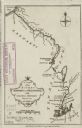
| Description: | Map of the Kenebec and Chaudiere River from the Atlantic Ocean to the Saint Lawrence River. Cities, forts, lakes, and tributaries along the two rivers are ... |

| Date: | 1776 |
|---|---|
| Description: | Fairly detailed map of New York City and parts of Long Island. It shows streets, roads, wharves, ferries, ship yards, Fort George and the battery, public b... |

| Date: | 1776 |
|---|---|
| Description: | Map of the Delaware Bay, River, their shoreline, made to aid ships in navigating to Philadelphia. It is oriented with north to the right and shows inlets, ... |

| Date: | 1776 |
|---|---|
| Description: | Map of Virginia and parts of Maryland and Delaware (written "De La War"). It shows borders, counties, cities, towns, plantations (marked by landowners name... |
If you didn't find the material you searched for, our Library Reference Staff can help.
Call our reference desk at 608-264-6535 or email us at: